
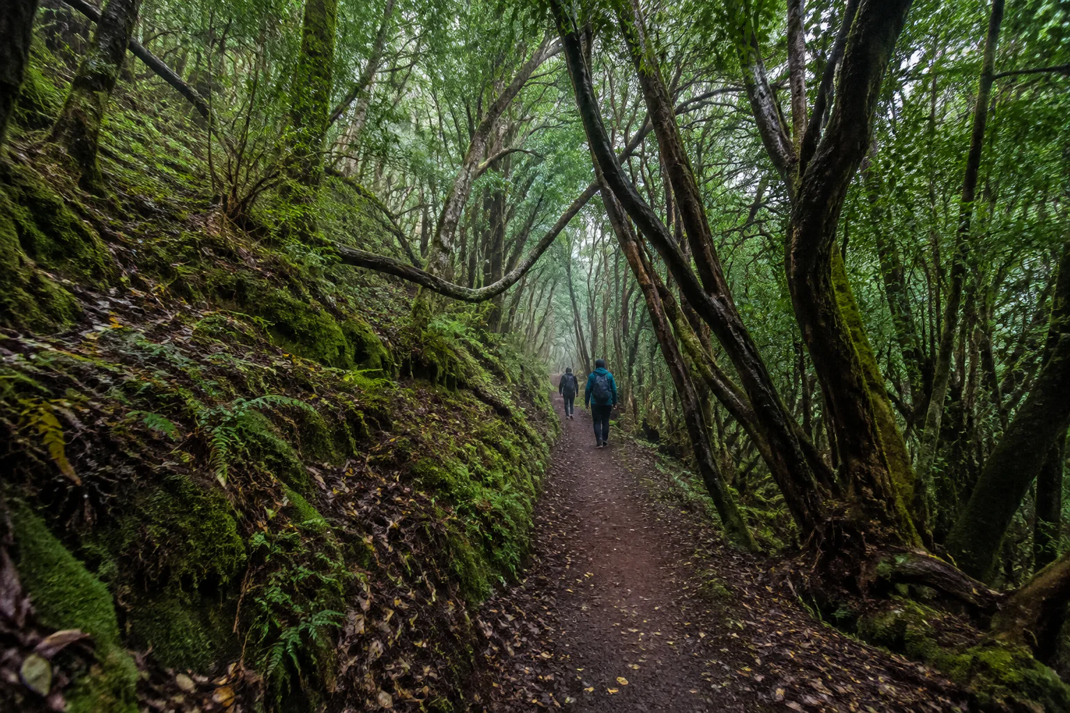
Guided hiking in Anaga
Walking Anaga with a guide makes sense for three concrete reasons: choosing the right route for whoever is actually walking, solving the logistics of a linear route in a poorly connected massif, and understanding a forest that without context stays at "very green". Worth knowing: some trails require prior authorisation, and the massif’s strict nature reserves do not permit commercially organised groups at all.
This piece is different from Anaga and walking, where I explain how to choose a route on your own. Here I cover the other side: what changes when you walk accompanied, what can be booked and what cannot.
I will start with the second, because almost nobody explains it.
What a guide cannot offer you in Anaga
Anaga Rural Park contains three strict nature reserves — Ijuana, El Pijaral and Los Roques de Anaga — with the highest level of environmental protection, plus Monte de Aguirre as a controlled-access zone.
El Pijaral, the so-called "enchanted forest", has a limit of 45 visitors a day and does not permit routes organised by companies or legal entities, nor by individuals operating for profit.
In practice that means no commercial guide can take you along that trail. Not me, not anyone. If someone offers it to you, something does not add up.
I say it here because it is one of the most searched routes on the island and because the information is hard to find. If El Pijaral interests you, you will need to book it yourself, individually, including up to a limited number of companions.
What a guide does add in Anaga
Choosing the right route
This matters most and is most underestimated. The word "trail" covers very different realities: there are surfaced half-hour walks and there are routes that drop to the coast and require solving the return.
The classic mistake is choosing from photographs. Photographs do not show the climb back or the state of the ground after a week of rain. The least experienced person in the group sets the level, always, and that decision is better made with someone who knows the real condition of the routes that week.
Solving the logistics
Anaga has narrow roads, scarce parking at popular spots and patchy mobile coverage. A linear route ending far from the start means arranging the return, and public transport enters the massif at limited frequencies.
Going accompanied turns that into someone else’s problem.
Understanding what you are looking at
The laurel forest is a humid woodland that once covered much of southern Europe and survives here thanks to the trade winds: moisture condenses on the leaves and drips to the ground. It is a forest that waters itself from mist.
That single fact changes the walk. It explains why Anaga is green on a dry island, why mist is not bad weather but the normal climate of the place, and why you cross from laurel forest into fayal-brezal within a few metres on reaching an exposed ridge.
The massif was declared a rural park in 1994 and recognised by UNESCO as a Biosphere Reserve in 2015, holding one of the highest concentrations of endemic species in Europe.
Permits, made clear
| Situation | What you need |
|---|---|
| Most waymarked trails in the massif | Nothing. Free access |
| Strict nature reserves (El Pijaral, Ijuana, Los Roques de Anaga) | Prior authorisation, with a daily cap. No commercial groups |
| Monte de Aguirre | Controlled-access zone |
Authorisations are handled through the Cabildo de Tenerife’s Tenerife ON platform. Slots are released every Monday at 07:00 Canary time, you must be registered and validated, and the booking document has to be carried, printed or on your phone, to show if there is a check.
Always verify the current position before you travel, because conditions and caps can change.
Real risks in the massif
The Cabildo itself warns of three specific hazards in Anaga: falling rocks, slippery ground and sudden temperature changes.
Add to that an important seasonal warning: in summer you should always check the wildfire risk level, because there may be pre-alerts and associated restrictions. It is public information, available through the Cabildo’s channels.
None of this makes Anaga a dangerous place. It makes it a place where footwear matters and improvising is expensive.
What to bring
- Closed shoes with good grip. The most important item by a distance. Roots and wet rock are slippery.
- A light waterproof or windproof, even if the south is at twenty-five degrees.
- Water and something to eat. Facilities inside the rural park are limited.
- Layers. There is a real difference between a windy ridge and the forest interior.
- A downloaded or paper map. Coverage is not reliable across the massif.
How I can help
I prepare private low and mid-mountain routes agreed with your group: the itinerary is decided according to your real pace, the date, the state of the access routes and the expected conditions, and it is confirmed in writing before booking.
I hold the qualification of low and mid-mountain trail guide (AFDA0611), which includes the first-responder and first-aid unit, and the activity is registered for active tourism (TA-4-0026356.16), with the public liability and accident or assistance insurance the regulations require. I am also an official tourist guide of the Canary Islands (GTI-289).
I do not publish a fixed route, distance or difficulty, because it would not be true for every booking: each outing is agreed with whoever is walking.
If what you want is not a hike but a day combining city, forest and a local table, there is another format: La Laguna, Anaga and a guachinche, with a short walk inside a broader day. They are two different things and worth not confusing.
Frequently asked questions
Can I book a guided route through El Pijaral? No. Anaga’s strict nature reserves do not permit commercially organised routes. The booking is individual and each visitor arranges it through Tenerife ON.
Do I need a permit to walk in Anaga? For most trails, no. Only the strictly protected areas require one. Check on Tenerife ON before counting on a specific route.
What fitness level is needed? It depends entirely on the route. There are walks under an hour with no meaningful ascent and others of several hours with long descents to the coast. Tell me who is walking and I will tell you what fits.
Is it a good idea with children? With children who walk comfortably, yes, choosing short surfaced routes. What usually fails is the driving time to the massif, not the walk.
What if there is mist on the day? Mist is the forest’s normal climate and it improves it visually. What disappears are the views from the viewpoints. Safety and visibility are checked before setting out and, where sensible, the itinerary is adjusted.
What is the difference between laurel forest and fayal-brezal? Laurel forest is the mature cloud forest, with large glossy leaves. Fayal-brezal is a more open, tougher formation typical of ridges and wind-exposed ground. You cross from one to the other in a few metres.
Can I reach Anaga by public transport for a walk? Partly. There are services into the massif, but at limited frequencies that heavily constrain a walk’s timing. I cover it in how to get around Tenerife without a car.
Before booking a route
Check the state of the trails, the authorisations in force and, in summer, the wildfire alerts at tenerifeon.es.
And if you want the route agreed with your group, write to me telling me who is walking, your experience and your dates.
→ Check availability · Anaga and walking · What to see in La Laguna
Qualifications, registrations and professional associations
Official Canary Islands Tourist Guide, Starlight Guide and low and medium mountain route guide.
- Official guideGTI-289
- Starlight Guideno. 40
- Low and medium mountainAFDA0611
- Active tourismTA-4-0026356.16
- Tourism intermediaryI-0005095.1
Registered active tourism activity with the current civil liability and assistance or accident insurance required by law.